
Marrickville floods. Today’s residents know this very well. Marrickville has always flooded, but it only became an issue when European settlers arrived, took possession, and set themselves down permanently on the land.
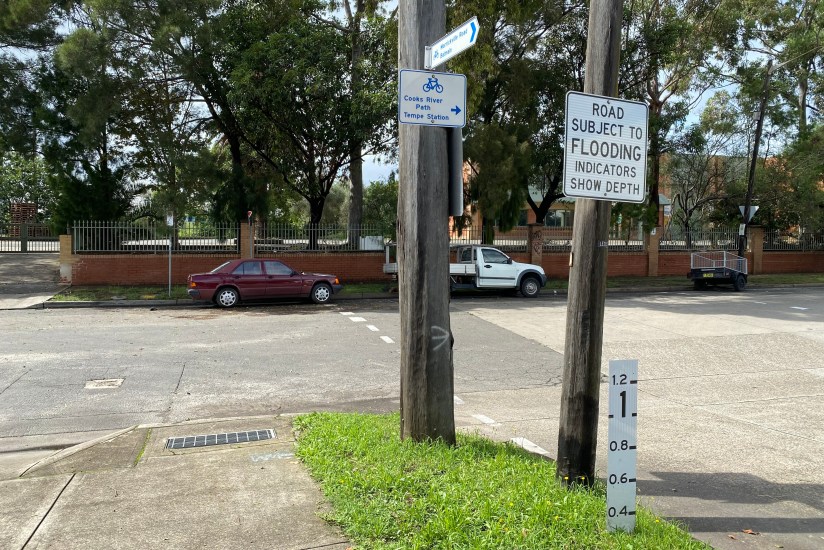
Photo: Rod Aanensen
Prior to that, the Gadigal and Wangal had occupied the land for millennia and, with the knowledge that brings, had the wisdom to move over it and adapt to its changing nature.
Marrickville is situated in a basin. When water falls on the surrounding areas – such as Newtown, Dulwich Hill, Stanmore and Petersham – it flows down into the basin and via a number of streams eventually makes its way into Cooks River.
With heavy rain, a swollen Cooks River will flood along its low-lying Marrickville banks and be slow to absorb storm water. And the river is tidal. Water from high tides or storm surges moves up the river acting as a barrier to water flowing downstream.
With all that water collecting in the basin and a flooding river, Marrickville was not an ideal place for a settlement.
Before the modern era this natural phenomenon was plain to see. But with development a lot of it has been covered over, either with property, parks, roads, or railways.
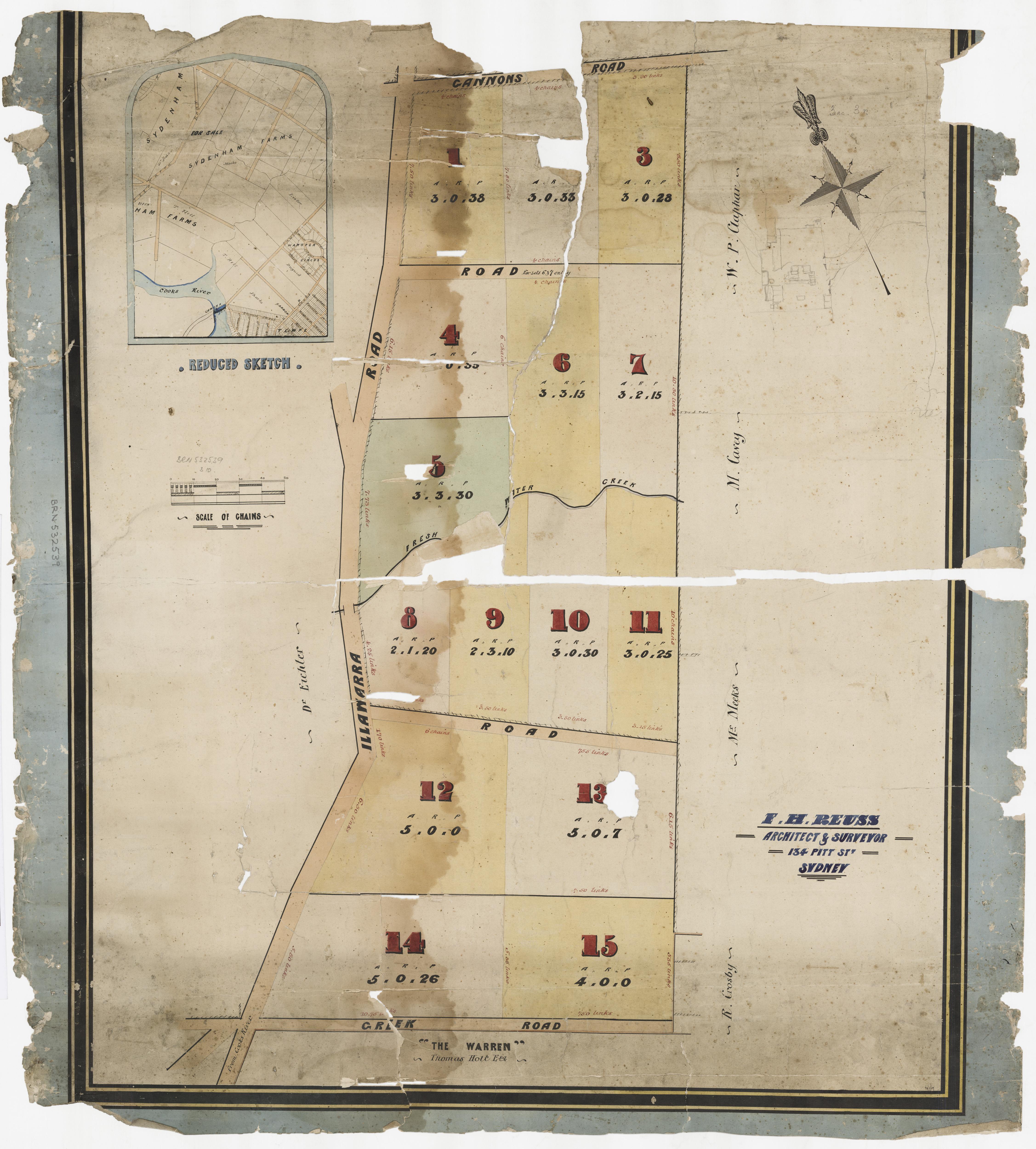
Sale of Portion of Sydenham Farms. F.H. Reuss, Architect & Surveyor.
Stay Library of NSW. https://collection.sl.nsw.gov.au/record/74VK2LNLemeX
National Library of Australia. https://nla.gov.au/nla.obj-230292090
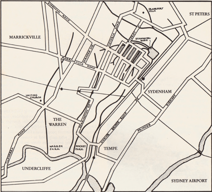
When Marrickville railway station floods, it highlights the fact that the line sits on a creek bed running east. The creek bed once joined Gumbramorra Creek, which flowed down to Cooks River along the line now occupied by Carrington Road; a road that floods regularly.
The eastern end of Marrickville Road runs across the path of the Gumbramorra Creek; another section of road susceptible to flooding.
Where there is bad flooding in Marrickville, you will find a low-lying area with a creek or water channel of some sort.
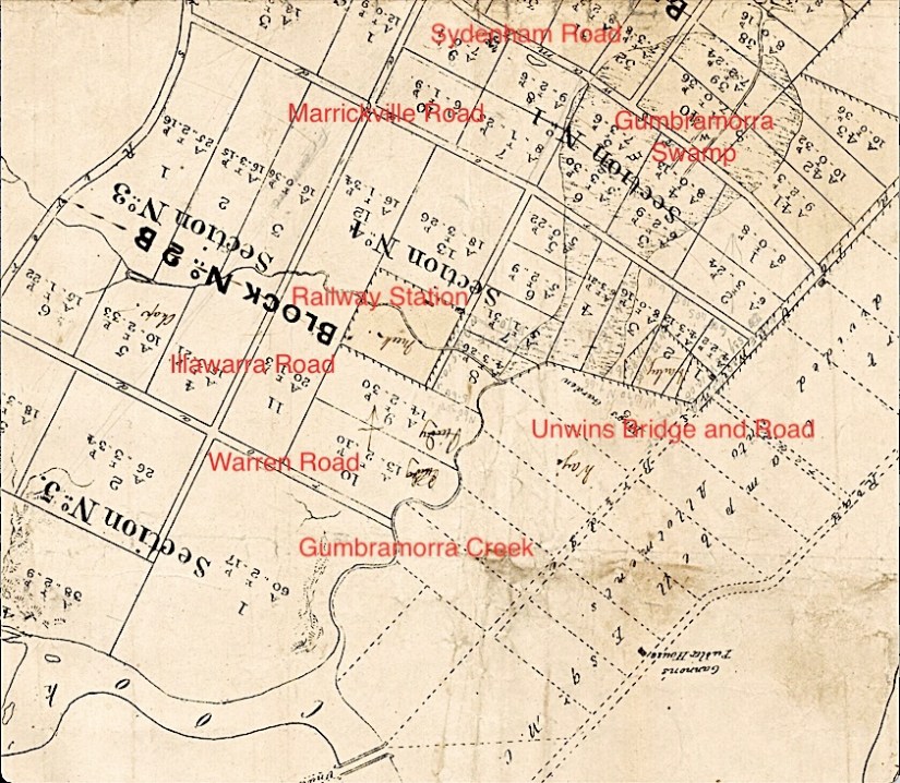
A major feature of Marrickville at the time European settlers arrived was Gumbramorra Swamp. This large area collected a lot of the rainwater from around, particularly Newtown, Enmore and Petersham, and then slowly drained it along Gumbramorra Creek into Cooks River. Today its core can be outlined by following Victoria Road from Edinburgh Road to below Sydenham Road (previously Swamp Road) then across to Sydenham Railway line and back up to Edinburgh Road.
It was this area which was to flood, sensationally, in 1889, leading to scandal, shame and action.
‘Plan shewing the subdivision of Petersham Estate 1850-1859’ (Detail)
National Library of Australia. https://nla.gov.au/nla.obj-229921124
The 1880s were a boom time for Marrickville and much of Sydney. Marrickville’s population exploded from about 3,000 to 13,000 residents drawn by industrial scale enterprises. A leather works on Victoria Road (Wright, Davenport and Company, later just Davenport and Company) employed 350 people.
The pressure to produce more housing was great and many of the old estates were divided up and sold in allotments. Just as important was making housing affordable as the market was also booming. Many developers and other speculators were making large profits from either buying and selling land or buying up lots, building on them and selling on.
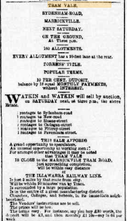
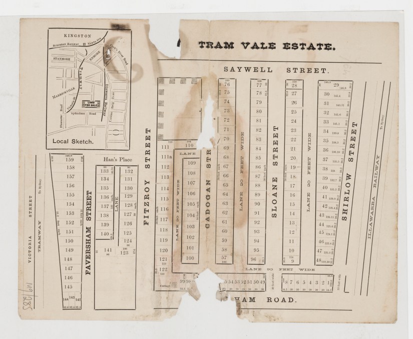
In 1878, Thomas Saywell, a man described as the quintessential capitalist, who today might be called an entrepreneur, purchased a large part of Gumbramorra Swamp. Although he had made most of his money as a tobacco merchant, he saw an opportunity to branch out into brickmaking in Marrickville. He established a brick works in Fitzroy Street but quickly sold the business to Leslie Johnson (Johnson Brothers) and William Stuntz. (See Building Blocks of Empire for some of their story).
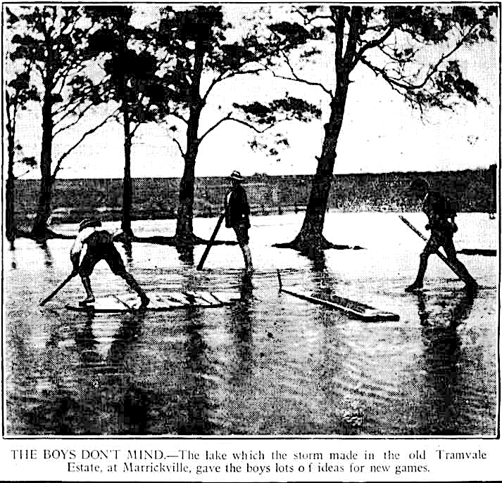
Before moving on, Saywell also subdivided a large part of the swamp known as Martin’s Paddock and Kingsbury’s Paddock and put it up for sale as ‘Tram Vale’ to capitalise on the laying of a tram line down Victoria Road. These paddocks were actually mudflats.
The Sydney Daily Telegraph 15/11/1881 Page 4. https://trove.nla.gov.au
In this fevered development environment, the actual environment hardly figured at all. Marrickville’s low-lying areas were causing serious problems for the population. Not just storm water was flowing down into Marrickville from Newtown and elsewhere, so was raw sewage. The smell was appalling and typhoid fever was common. In May 1886 seven people died of typhoid fever in Marrickville and St Peters.
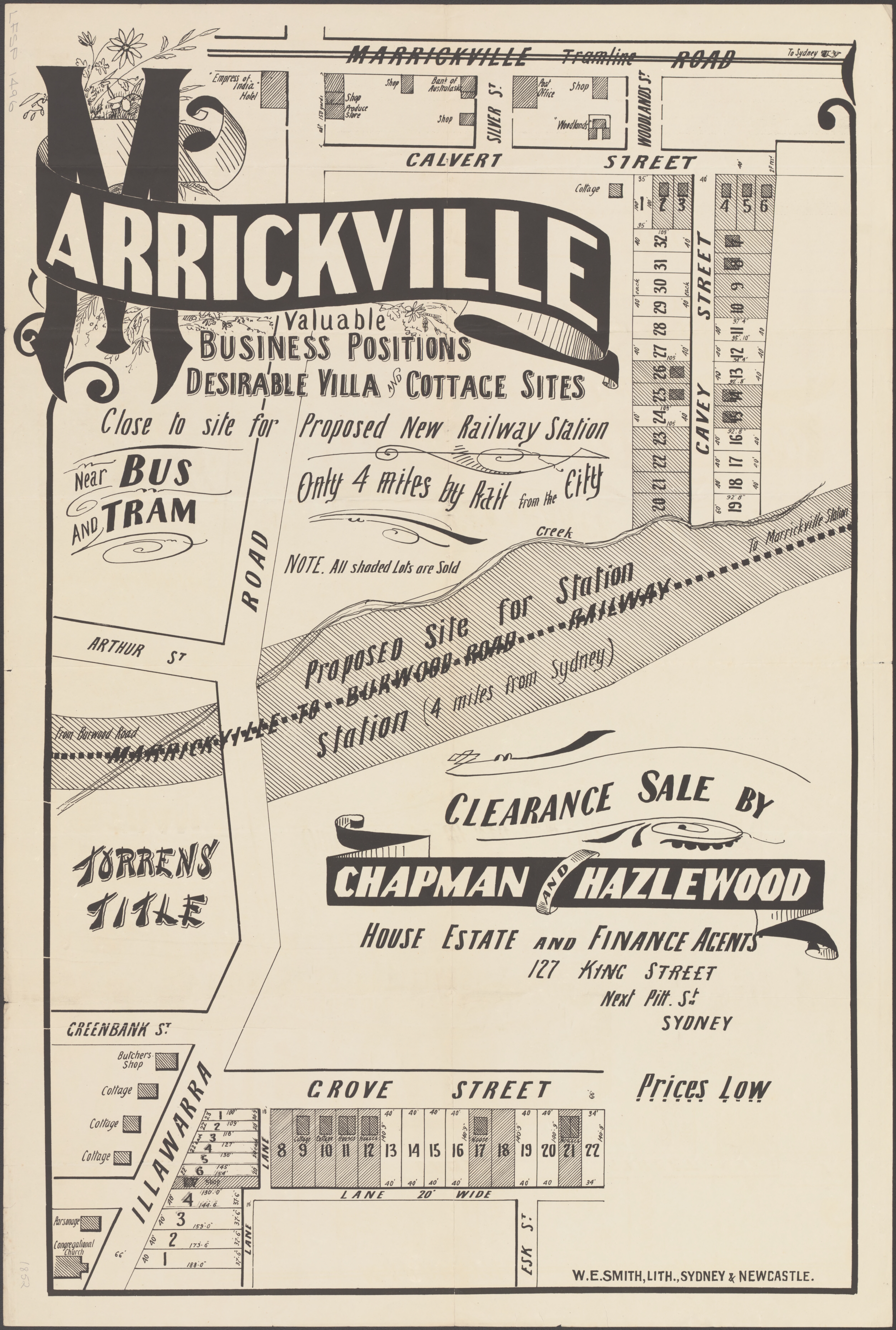
State Library of NSW. Z/SP/M9/285 – Tramvale, Marrickville. https://collection.sl.nsw.gov.au/record/74VvdB2DaX8Z/m2bQDea5RmLq2
So, though the land was being sold cheaply to attract the working-class buyer, not many took up the offer. Three separate auctions of land took place from November 1881 to November 1882; many purchasers were landlords.
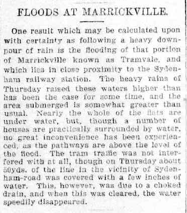
Then in 1884 a deluge fell on Sydney. Tram Vale, from Victoria Road to the Sydenham railway line, and all the land down to Cooks River was under about 2 or 3 feet (1 metre) of water.
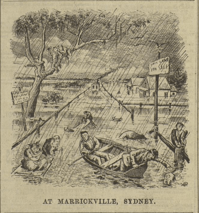
“Splendid building sites for sale”. A steam tram is in the distance.
The Bulletin 11 /7/1884 Page 14.
Image: National Library of Australia. nla.obj-239846500
The Sydney Morning Herald reported “A score or more of … residences are in the midst of a swamp, and it is sad to think of the discomfort and sickness which will almost assuredly result from residences being placed in such insanitary places.”
The following year Tram Vale flooded again and The Daily Telegraph, editorialising on “The Typhoid Plague”, stated: “There are large portions of Marrickville…occupied by hundreds of houses, on which no residential building ought to have been erected. It is a fact known to the Government, and to a large body of the citizens, that scores of houses in Marrickville stand on allotments that are below the level of the sea. We subdivided and sold and built, thinking only of present gain”.
Marrickville Council had been petitioning the state government for a comprehensive drainage system (sewage and stormwater) for a number of years. They couldn’t afford to do it alone and thought that perhaps a united group of councils could spur the government into building a Western Suburbs Sewerage Scheme. In fact, the government had heeded their call and was looking into such a scheme.
But it was the floods of 1889 that made the difference.
Between Friday 24 May and Tuesday 28 May, 508mm of rain fell on Marrickville; about 406mm of that in the last three days. To give you a comparison, 309mm fell on Marrickville Golf Club between Wednesday 23 February and Sunday 27 February 2022; Wednesday 23 February saw 170mm fall on the Golf Club and Marrickville was named the wettest place in NSW that day.
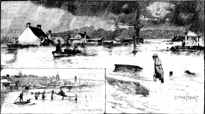
The Sydney Mail and New South Wales Advertiser, Saturday 8 June, 1889, Page 1197. https://trove.nla.gov.au
As in 1884, all of Tram Vale from Victoria Road to Sydenham railway line was covered in water. Water also covered all the ground from Sydenham Road to Cooks River at the eastern end of Marrickville Road. Reports put the depth at between 6-10 feet (around 2 to 3 metres). The lower parts of Chapel Street, Victoria Road, Sydenham Road, Marrickville Road and Meeks Road (now Carrington Road) “could not be seen for water”. The trams were stopped and boats were rowed up from Cooks River to help rescue people trapped in their homes. You will note that all these roads make up the Gumbramorra Swamp and Creek.
Altogether, about 30 households in Sydenham Road, Meeks Road, Faversham, Fitzroy, and Railway Streets (150 people) were made homeless. Some were housed in people’s homes and an empty row of terraces in Edinburgh Road. The majority (70-80) were taken in by William and Lina Ipkendanz, the owners of the Royal Exchange Hotel on Marrickville Road. The men bunked down in the billiard room, while women and children occupied rooms upstairs.
The story was too good for newspapers to pass over. When more heavy rain fell in Sydney in 1890 reporters went immediately to Tram Vale. Then again in 1891 and twice in 1892 and 1895. It was not the sort of publicity wanted by the aldermen (councillors) of Marrickville.
Marrickville viewed itself as a progressive, thriving, business-oriented suburb. All the talk of Tram Vale and the “flooding at Marrickville” was doing it no good.
The Daily Telegraph 9/02/1895 Page 5. https://trove.nla.gov.au
The aldermen considered a plan to set the media straight and make them name Tram Vale in their reports, not Marrickville. To help them differentiate, Council asked the state Public Works Department to name the railway station at Sydenham ‘Tram Vale’ and the new station on Illawarra Road ‘Marrickville’. Not wanting the Tram Vale name attached to them, the St Peters Council objected. It is Sydenham Station today.
In 1898 Alderman Scouller came up with the idea of changing Marrickville’s name, claiming many people were ashamed to say they lived here. He thought ‘Hampton’, but would leave it up to others to provide two names for the electors to vote on. His proposal failed, but as late as 1905 Alderman Butler had another try, wanting to change the name to ‘Dulwich’.
The Sun 26/5/1925, Page 16
https://trove.nla.gov.au
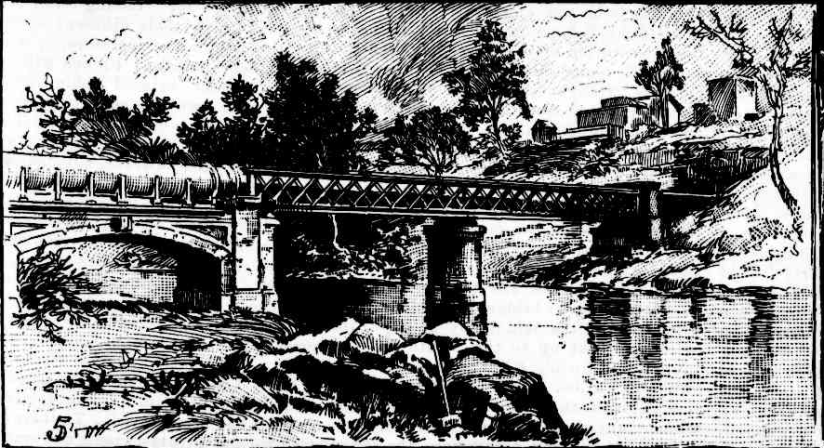
The Western Suburbs Sewerage Scheme (WSSS) was finally up and running in 1899. It consisted of three brick channels (Eastern, Central and Western) running into Cooks River to deal with storm water (see diagram below). The Western Channel can be easily seen in Mackey Park. WSSS also had a sewage system dealing with sewage from Newtown, Marrickville and St Peters.
Several of the structures involved in the system are heritage listed – Sewage Pumping Station No. 271 (Carrington Road), Premier Street Sewer Vent and cottages, and Cooks River Sewage Aqueduct.
The Illustrated Sydney News, 21/05/1892, Page 17.
https://trove.nla.gov.au
While the WSSS was helpful, it didn’t solve the problem of flooding at Tram Vale and its surrounds. Flooding remained a very real problem until the 1930s.
In 1935 work began on what would be called the Sydenham Pit and Drainage Station 1 (also heritage listed). Anyone who has boarded a train to the city and looked out just past Sydenham Station at Garden Street will have seen a large 9-metre-deep ‘cement pond’ (actually lined with slabs of sandstone), currently obscured due to work on the Metro train line.
‘The 1889 Marrickville Floods and the Tramvale Estate Scandal’, Richard Cashman.
Marrickville Heritage Society Journal ‘Heritage’ No.6. Page 27.
The plan was to create drainage channels through Tram Vale and areas north of Marrickville Road, which would feed into the pit and then be pumped into the Western Channel of the WSSS.
All the severe flooding areas have been relieved with these works, except for the banks of the river. In May 2012, 100mm of rain fell in six hours and water was 1 metre above road level on Riverside Crescent submerging many cars. ‘Flooding at Marrickville’ is still making the headlines and is likely to for some time.
Rod Aanensen
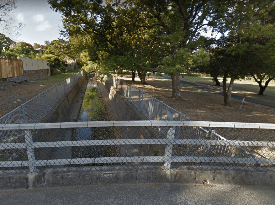
Photo: Google Maps.

Thanks for such an interesting article. Stormwater drains now installed at the lowest point in Riverside Crescent seem to have prevented any recent flooding. Ibis and frogs are
enjoying the new ponds on the Golf Course!
LikeLiked by 1 person
really enjoyed article. I miss living there, have visited often, till 2018.
LikeLiked by 1 person
An excellent article – I think the photograph at the end of the article is the end of Western Channel
LikeLiked by 1 person
Thank you Robert. I apologise for the long delayed response and appreciate your correction. I have changed the caption accordingly.
LikeLike
Very informative and interesting article Rod. Many Thanks
LikeLike
thank you for your most interesting history report on flooding etc. From growing up in Malakoff street no: 20 down towards Sydenham road,house was flooded out numerous times up too the early 60’s.
LikeLike